Re: Alderpoint Loop 9/12
Posted: Mon Sep 23, 2013 3:25 am
Sorry, no.
Tahoe is much taller than it is wide, so South Lake Tahoe would be at least 3/4's of a map height below the bottom of the map, maybe more.
As below:
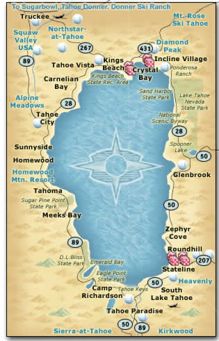
But, of course Carson City, Virginia City, and Reno are all east of Tahoe, as the state line runs straight up through the center of the lake, and Reno is almost directly north of Carson City, with Virginian City being northeast of Carson and southeast of Reno. So, the whole map is a fiction anyway that just slightly references reality. They have placed Reno Nevada deep in California just about exactly where Truckee actually is. Actually, the map says it is "The Ponderosa in Nevada," and, as drawn, they've put about 2/3's of it in California, just as about 2/3's of Lake Tahoe is in California.
Interestingly, one genuine realistic factor is that the Ponderosa Ranch at Lake Tahoe is (or was) in Incline Village, which actually is within the border of The Ponderosa as shown on the map you posted (although not where they show it on their map - it actually would be over on the south-east corner of The Ponderosa). Also, they show the lower Truckee River just about exactly true to reality (from the lake to their Reno), except that they show it hitting Reno where it actually hits Truckee (they have it all wrong after it leaves their Reno). In real life, it takes a sharp turn to the east and travels quite a ways east and a little north to get to Reno after it leaves Truckee. Interstate 80 pretty much follows the Truckee River from Truckee to Reno.
Washoe Lake is also real and really is between Carson City and Reno, it's just that Reno is directly north of Carson City, so Washoe Lake is as well.
It's like they took everything northwest of Tahoe and just turned it 90 degrees to the left and set it over the top of the lake, conveniently fitting everything into a format wider than it is tall . . . just about the shape of a TV screen. Even the shape of Washoe Lake has been turned 90 degrees.
Tahoe is much taller than it is wide, so South Lake Tahoe would be at least 3/4's of a map height below the bottom of the map, maybe more.
As below:

But, of course Carson City, Virginia City, and Reno are all east of Tahoe, as the state line runs straight up through the center of the lake, and Reno is almost directly north of Carson City, with Virginian City being northeast of Carson and southeast of Reno. So, the whole map is a fiction anyway that just slightly references reality. They have placed Reno Nevada deep in California just about exactly where Truckee actually is. Actually, the map says it is "The Ponderosa in Nevada," and, as drawn, they've put about 2/3's of it in California, just as about 2/3's of Lake Tahoe is in California.
Interestingly, one genuine realistic factor is that the Ponderosa Ranch at Lake Tahoe is (or was) in Incline Village, which actually is within the border of The Ponderosa as shown on the map you posted (although not where they show it on their map - it actually would be over on the south-east corner of The Ponderosa). Also, they show the lower Truckee River just about exactly true to reality (from the lake to their Reno), except that they show it hitting Reno where it actually hits Truckee (they have it all wrong after it leaves their Reno). In real life, it takes a sharp turn to the east and travels quite a ways east and a little north to get to Reno after it leaves Truckee. Interstate 80 pretty much follows the Truckee River from Truckee to Reno.
Washoe Lake is also real and really is between Carson City and Reno, it's just that Reno is directly north of Carson City, so Washoe Lake is as well.
It's like they took everything northwest of Tahoe and just turned it 90 degrees to the left and set it over the top of the lake, conveniently fitting everything into a format wider than it is tall . . . just about the shape of a TV screen. Even the shape of Washoe Lake has been turned 90 degrees.
